

I thought I would share with you some of the steps I’ve been going through to plan for this next hike.
When I first started hiking, planning a long distance hike was much harder because I didn’t have the advantage of all the information to be found on the Internet. Luckily for me, most of the national scenic trails have a trail organization which has put together maps and planning guides. In addition, there is an app that most hikers use on their phones telling us where the towns are. It includes comments left by other hikers sharing their town experiences and what was available for them in each town. These are invaluable tools for the thru hiker.

As much as I always want to start packing my food boxes, there’s so much that I have to do before that. This part of the process always reminds me of the importance of laying a good foundation for any task. After packing the boxes I have something big to show for my work. When I take the stack of boxes to the post office, I feel like I have really accomplished something. On the other hand, much of the work I do before I pack the boxes seems tedious and leaves me with little to show for all my work except for a list on a piece of paper. Nevertheless, I’ve learned the importance of not jumping ahead to packing the boxes before I have laid the groundwork.
My first task was to figure out mileage between the towns. Some are more than thirty to fifty miles away from the trail. Others might be right on the trail but are much smaller towns with fewer supplies. Sometimes towns are really close together and I have to choose one over the other. Other times they are more than 100 miles apart. I don’t like to resupply every few days so I tend to skip towns if they’re less than three or four days apart. I try to choose towns that are closest to the trail and about a five day hike from each other. I use 15 miles a day as a guide for how long it will take me to get from one town to the next. I add a day if I know it’s going to be a particularly difficult section. There will be a number of them on the PNT. Occasionally I’ll subtract a day or go lighter on the food if it seems the trail will be particularly easy. On this trip, I’ll have a number of four and five day stretches between towns, but I’ll also have 8 to 10 day stretches between resupplies.
The next thing I figure out is how easy it is reported to get in and out of town either by hitching or trail angels. Then I look at what kind of grocery store is in town. I also call around to see if any of the stores in town sell the kind of fuel I need for my backpacking stove, which are small Ispro gas canisters. If a town has all of that, sometimes I plan on buying when I get there. A number of these small towns don’t carry the fuel so I mail it along with some of the harder to get items, and buy most of my food when I get there. Some towns have no proper grocery store, and sell only snack foods. Some of the resupply places aren’t even towns, but are remote campgrounds or resorts that are back off dirt roads in the wilderness. In those cases, I prepare boxes to mail to myself with everything I’ll need. I used to mail my boxes general delivery to the post office but that had some problems, the biggest of which was that if I arrived on a Saturday afternoon, I couldn’t get my box until Monday morning. Some post offices are not open on Saturday and have limited weekday hours. Some post offices won’t hold the package for longer than two weeks, and some of the towns, such as Polebridge, Montana, don’t have post offices. What I have started doing is utilizing the Internet to help me identify businesses in town, choosing ones that are open seven days a week. I make a bunch of phone calls explaining what I’m doing and asking if they would mind if I mailed a package to them. Most of them are amiable to this. Using the app, I can sometimes discover if there are established hostels or trail angels in town who are known to readily accept packages. In this case, I contact them out of courtesy to double check and I always make sure to send a thank you after they tell me they will gladly accept my package.
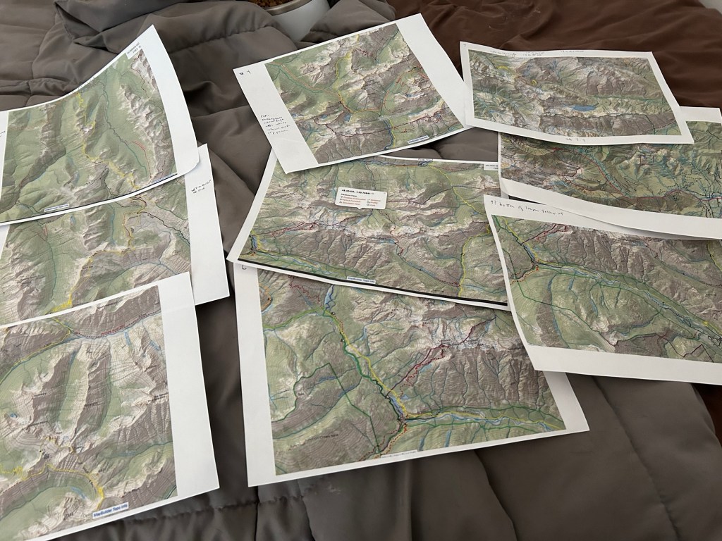
Once that’s done, I can finally start packing my boxes, although for the Pacific Northwest Trail, there was more I had to do first. There is one fire closure on the trail from a fire that happened a few years back. That section of trail has many trees that continue to fall and is considered unsafe to walk through. As a result, I had to figure out a detour of about 100 miles. What complicated my planning was that the detour comes at the end of about 120 miles since the last town to resupply in and I didn’t want to add another hundred miles to that. In addition most of the possible detours included either a very dangerous road to walk on or permits in the backcountry which were reported to be very difficult to get because it is in the very popular northern Cascades park. I spent many hours making phone calls to different rangers and studying routes that other people had posted online.

Pat Kosher, a trail angel from the Ice Age Trail has been superb at doing some research for me, which is easier for him on his full computer than it is for me on the tiny screen I have with me. Once I established a route and found out that I probably could get permits for it, I utilized the library in Santa Fe to help me print out paper maps so I would be able to find my way.

Getting to the point of being able to finally pack my boxes has taken a full weeks worth of work and way too many hours of staring at a computer screen. But I try to remind myself to be grateful that the information is fairly easy to find compared to what it used to be. When I thru hiked the Pacific Crest Trail in the 1980s. there was very little information to be had. Even the one large, two volume book that was purported to be a guidebook was somewhat useless. I remember standing in 20 feet of snow with my map and compass trying to decide which mountain pass I had to go over. When I looked in the guidebook for the PCT, this is what it said. “You are now standing in a field where the grass ripples at your feet like creame de menthe over vanilla ice cream.” It may have been poetic, but it did nothing to help me find my way.
One thing I’ve learned in the planning is that sometimes I need to get up and take a break from it. I either go for a walk or eat some food, which I do every few hours. So now I am going to take my own advice and take a break from writing. The next time I post I’ll talk about part two of the planning process.

Leave a comment