
This is my attempt to answer the questions I was asked about my route and what I anticipate as challenges.
To be honest I am still figuring a lot of this out. I am going strictly north to south. I started at the Canadian border in New Hampshire and hope to end 410 miles later at the ocean in Long Island Sound. To date (June 18 as I write this) I have completed 47 miles in four days of paddling. I actually did more than that as I paddled some lakes which form the upper CT River twice. There were some unpaddleable sections that I skipped.
I need to return home a number of times this summer. Two and a half years on I am still embroiled in a nasty divorce which requires my periodic attention. And I am finally engaged with a therapist who understands trauma and dissociation. Realizing after my husband left that I was again swamped with the suicidal pain from my childhood, I sought whatever help I could find. Being active in the outdoors helped me a lot, as did all of the kind people I have met along the way. Truly their kindness has done a lot to help me recover and heal. But as this AEDP (https://aedpinstitute.org/about-aedp/ ) trauma therapist says, it is almost impossible to recover on one’s own from abuse which causes dissociation. I was lucky to land in her lap and am making it a priority to return home to make my appointments with her. Thus I will be out for a week or so, home for a few days and then out for another ten days or so depending on her summer schedule.
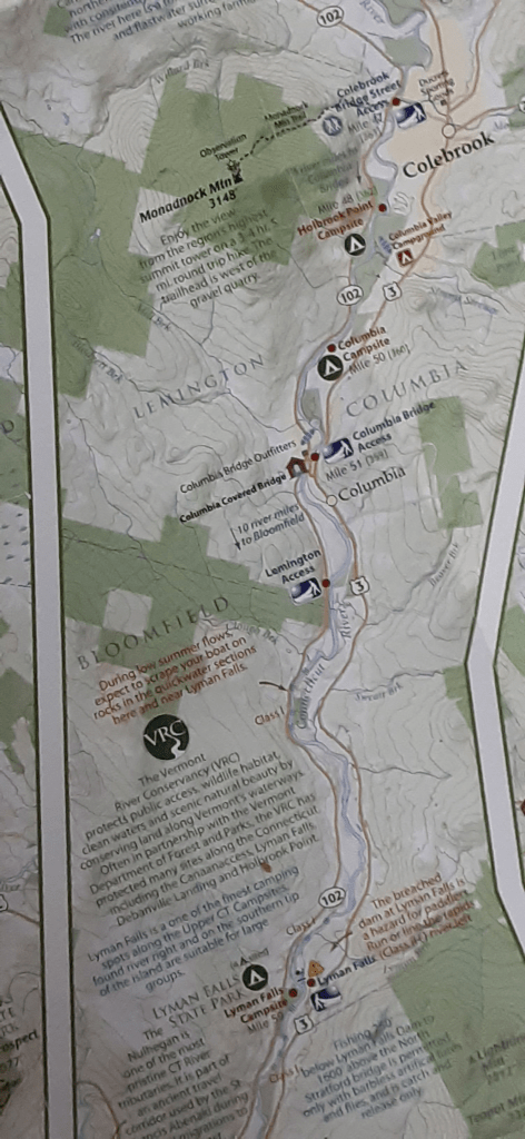
So one of my first challenges is getting rides to and from the river and making it to my appointments. This is where having Dottie along is a blessing. We can take two cars, leaving one at the put in and one at the take out. Then we just have to make sure we paddle fast enough to arrive in time! I don’t want to paddle in lightning or even in a severe downpour, and I don’t want to feel like I am always rushing. Thus I will plan for a leisurely 20 miles per day to start. It is definitely possible to paddle thirty or more miles in a day, and some days we might do that, especially if we have to make up for a shorter rain day. Portages will also take up some time, as will finding places to get an ice cream. 😊 I want time to write and to enjoy the river, so at least for this first stretch I will aim for about 20 miles per day. I am writing this without a real sense of where the possible campsite are so it could change a lot!

My biggest concern is making sure I find the take outs before being swept through a class III rapid or over a dam. I have a fair amount of information about the northern 280 miles of the river thanks to the Connecticut River Paddler’s Trail. (https://www.connecticutriverpaddlerstrail.org/crpt7/) Their map and phone app are excellent. I have a series of maps for the river in Mass and CT from the Connecticut River Conservancy (https://www.ctriver.org/) though they are not as detailed. I have not yet had the time to really look at them in depth. Like my bike trip which was planned out a day or two in advance of each day’s travels, this trip will be put together as I go. As much as I sometimes like to have very specific plans, I have learned that sometimes I have to just let go and plan it one or two days at a time.
I have heard that I have to watch out for tides as I get closer to the ocean. And on some stretches of river I might have to contend with motor boats. In some places I might I have to hang my food at night to keep bears out of it. Unfortunately I might also have to be careful of humans. I read about one woman who had her boat and gear stolen when she left them to grab a bite to eat. Luckily some people managed to find her stuff and return it to her.
I have to be careful where I camp or stop for lunch. When a dam releases water, the river can rise quickly and wash out what looked like a lovely camping spot. Some people have lost boats when this happened because they left them too close to shore. My friend Karen Deets, who is a real map aficionado, kept me aware of fires when I was on the CDT. She has agreed to keep me aware of scheduled dam releases during my paddle..

Being on the water adds a new layer of complexity to keeping gear dry. Hopefully my dry bags will work. I don’t want to drop my phone in the river while taking a picture. Nor do I want to have my mini iPad ruined if I capsize. I am leaning towards taking the plastic Pacifica kayak so I will be less concerned about boat failures and capsizing. But I sure will have to work harder to paddle the thing. Unlike the solo Firebird canoe or the white water kayak, the Pacifica feels like a tank in the water.
Getting water might be an issue. I am not sure I really want to drink the CT River, especially as I get into more farmland and factory runoff. I will carry a filter but I hope to be able to fill up on land. I find this so ironic as I will be on the river. When I hiked in the New Mexican desert on the CDT I drank some really questionable water that had cows standing in it. But somehow I find the concept of drinking farm chemical waste even more distasteful. I can carry a fair amount of water in a boat, but I don’t want to have to portage it. Every pint of water weighs one pound.
In general I am not too worried about anything. Having Dot along gives me a sense of added security. And while this journey feels like it is pushing me further into the unknown than the other trips did, I keep reminding myself that there were an awful lot of unknowns on the CDT and the bike trip. I got through those and if I am going to live by the words I write, I must stay relaxed and believe I will get through this trip just fine.

Leave a comment